
P-Band Radar: A New Frontier in Forest Biomass Measurement
The assessment of forest biomass plays a critical role in understanding carbon storage and forest management. Indirect measurement systems blend conventional field sampling techniques with advanced remote sensing technologies, such as light detection and ranging (lidar). In regions like North America and Europe, where forest management practices are well established, foresters routinely assess tree metrics, including height and diameter.
Challenges in Mapping Remote Forests
Despite advancements in forestry research, many of the world’s forests, particularly in less mapped areas like the Amazon, remain poorly studied. Ground-level surveys have achieved depth in only a fraction of these vast forests—less than 20% of the Amazon has undergone thorough ground-based investigation. To evaluate biomass in these hard-to-reach regions, satellite-based forest monitoring emerges as the only viable option, yet current satellites lack the necessary equipment for effective tree monitoring.
Decoding the Limitations of Current Satellite Technologies
From a satellite perspective, tropical forests present as verdant carpets, concealing the complexities of individual tree structures beneath their canopy. Traditional radar systems, such as those on the Sentinel-1 satellites which use C-band wavelengths ranging from 3.9 to 7.5 centimeters, face significant limitations; these shorter radio waves reflect off the foliage and branches without penetrating the forest to reach the ground.
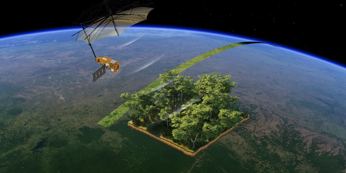
The Biomass Mission and P-Band Radar Technology
To address this deficiency, the European Space Agency (ESA) is launching a groundbreaking initiative known as the Biomass mission, which is designed to utilize P-band radar technology. This innovation employs longer radio waves—approximately ten times the length of C-band wavelengths—capable of recognizing larger tree components such as trunks and sizeable branches, where a substantial portion of forest biomass exists. However, the integration of P-band radar into a satellite presents a variety of engineering challenges.
Engineering Challenges of P-Band Radar Deployment
The necessity for larger structures arises from the scale of the P-band radar. “Radar systems scale with wavelengths—the longer the wavelength, the bigger your antennas need to be,” explains Dr. Scipal, a key figure in the Biomass project. Consequently, the satellite has been designed to measure two meters in width, thickness, and four meters in height, with its radar antenna spanning an impressive 12 meters in diameter. The engineering team at Airbus had to cleverly engineer this antenna to be foldable—similar to a large umbrella—to facilitate its launch aboard the Vega C rocket. Upon reaching space, an extensive unfolding procedure will be required, anticipated to take several days.
Regulatory Hurdles and Operational Limitations
Beyond size constraints, regulatory factors have historically hindered the deployment of P-band radars in orbit. The International Telecommunication Union (ITU) imposes strict regulations to prevent interference with specific radar frequencies, notably the SOTR (Single-Object Tracking Radars) utilized in the United States for missile detection. “The primary frequency allocation in P band is for huge SOTR Americans use to detect incoming intercontinental ballistic missiles. That was, of course, a problem for us,” notes Scipal. To mitigate interference, ESA agreed to operational limitations, including a requirement to deactivate the Biomass radar over North America and Europe.
Conclusion
The Biomass mission represents a significant leap forward in our ability to monitor global forest biomass, particularly in regions that have remained largely unexplored. By harnessing the power of P-band radar, ESA aims to improve our understanding of carbon dynamics in tropical forests, which is vital for climate change mitigation and sustainable forest management.
